ČEZ JIZERSKÁ 50
9. 2. 2025
1344 starting numbers remain.
15.5.2018
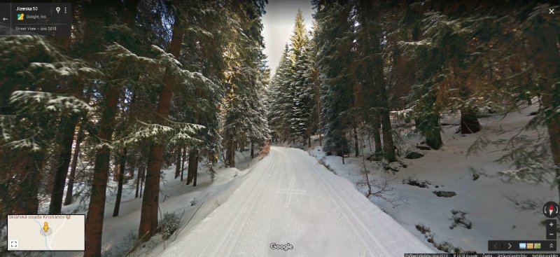
Not only the main track of the legendary Jizerska 50, but also the shorter races are already available for online viewing via the Google browser. On the maps, you can also use on your telephone or computer to comfortably browse through the complete track of the Jizerska 50 and also the ski tracks in the vicinity of the Josefův Důl Dam or in the Královka area.

This service can serve tourists, athletes and the local people all-year-round. In summer you get advice on which routes to go hiking or biking in the Jizera Mountains, in winter for a change, on which routes to go skiing. You can no longer get lost in the vicinity of Bedřichov, where the famous Jizerska 50 starts every year.
And if you were by chance unsure of the route, it suffices to open Google Maps, localize your position using GPS and use the 360° view to check the continuation of your journey. The browser will also help you better plan a trip or journey into the mountains, you will exactly know the difficulty of the gradients that await you.
Unique Google and Jizerska 50 Project
Google, which dispatched its Street View Trekker on the track of the Jizerska 50 on a snowmobile at the beginning of January published the results of its new year’s mapping prior to the start of this 51st year of the race, which was entered by a record 7,298 competitors on the third weekend of February. The scanning of the route for the Street View function in the Jizera Mountains in the Czech Republic was quite unique for two reasons: it was first ever scanning using a snowmobile and also the first collection, which was entered in Google Maps by the Czech partner of Google.
What is Street View?
Street View is a feature of Google Maps that is currently available to users in more than 80 countries of the world. Thanks to this feature, the users can use 360° views of the streets of various cities, but also natural and cultural monuments worldwide. Within the Czech Republic, virtual access is provided, among others, to all Czech monuments under UNESCO, many castles and châteaux as well as natural beauties. The most frequently visited places on Street View in the Czech Republic include the Gardens of the Prague Castle, the historical city of Český Krumlov or the Prague City Centre. Street View is available in the Czech Republic since 2007 and undergoes regular update to ensure that it gives the truest picture of reality.
What is Trekker
Mapping of difficult to access areas for Google Street View is made possible by the device known as the Street View Trekker. It is a backpack fitted with a surface camera system in such a manner that it is possible to easily carry it. Thanks to this, it can scan even narrow, difficult to access places and areas accessible only to pedestrians. The photographs are taken automatically about every two and half seconds when the operator is walking along; the camera is 60 cm above his shoulders. The photographic equipment is fitted with 15 lens pointing in all directions, weighs about 18 kg and 120 cm tall. The equipment gets optimal results at normal walking speed, but is also capable of functioning at a speed of up to 40 km per hour. The backpack was used for the first time to map the Grand Canyon in Arizona.
Pošli článek dál
×
9. 2. 2025
1344 starting numbers remain.
8. 2. 2025
596 starting numbers remain.
8. 2. 2025
756 starting numbers remain.
7. 2. 2025
255 starting numbers remain.
6. 2. 2025
302 starting numbers remain.
6. 2. 2025
217 starting numbers remain.
7. 2. 2025
Registrations will be open soon
7. 2. 2025
82 starting numbers remain.